
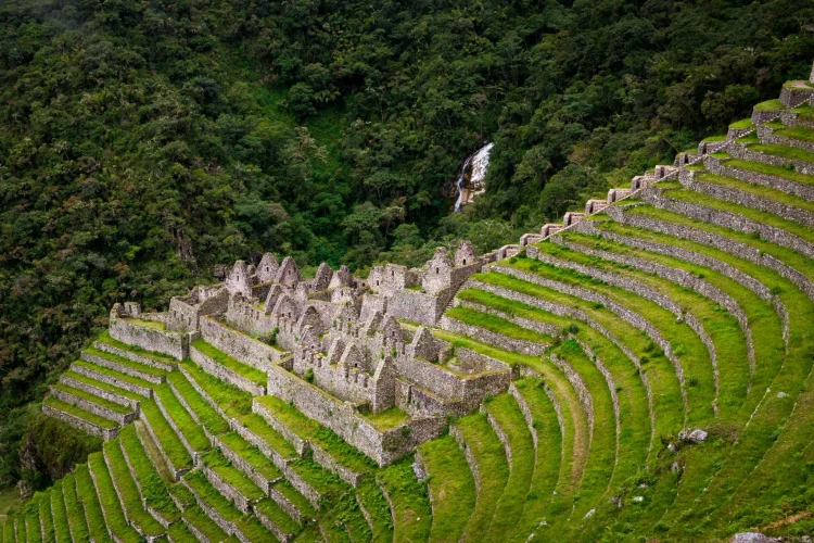
Hidden among green mountain slopes, Wiñay Wayna offers one of the most memorable sights along the Inca Trail. Agricultural terraces descend across a steep hillside, while stone buildings, stairways, and fountains reveal how Inca builders adapted their designs to challenging terrain.
This archaeological site deserves attention beyond a quick photograph before continuing toward Machu Picchu. Its layout offers a closer look at the relationship between agriculture, water, movement, and mountain landscapes. Understanding these features makes the visit more rewarding and helps explain why the journey itself holds so much historical interest.
You might be interested in reading: Trekking in The Andes | A complete guide for first-time hikers
What Does Wiñay Wayna Mean?
The name is commonly translated from Quechua as “forever young” or “eternally young.” You may also encounter the spelling Huiñay Huayna, reflecting different ways of representing Quechua sounds in written Spanish.
However, the familiar name should not automatically be treated as the original Inca name. Documentation published by Stanford University explains that Peruvian archaeologist Julio C. Tello named the ruins following archaeological explorations in the area during the twentieth century.
The name is also associated with an orchid locally known by the same expression, identified as Epidendrum secundum. Travel accounts frequently connect the flower with the site’s identity. This botanical association adds interest, but it should remain separate from claims about what the settlement was called or how its inhabitants understood it during Inca times.
Where Is Wiñay Wayna Located?
The site lies in Peru’s Cusco region, within the Historic Sanctuary of Machu Picchu. It occupies a steep mountainside overlooking the Urubamba Valley, along the final section of the Inca Trail before Intipunku, the Sun Gate.
Its elevation is generally given as approximately 2,650 meters above sea level. Since the buildings and terraces occupy several levels, this figure is best understood as a general reference rather than the elevation of every part of the complex.
The surrounding scenery combines forested slopes, deep valleys, and frequently shifting clouds. These conditions help explain the site’s distinctive appearance: instead of occupying a broad, flat plateau, its architecture follows the mountain.
Do not confuse it with Huayna Picchu. That name refers to the mountain rising behind Machu Picchu in many familiar photographs, rather than this separate archaeological complex.
History and Its Place in the Inca World
Wiñay Wayna belongs to the network of Inca settlements connected by mountain paths around Machu Picchu. Its location beside an important approach route, together with the effort invested in its architecture, suggests that it held significance within the surrounding territory.
The Wenner Gren Scientific Expedition investigated archaeological sites and Andean communities between 1940 and 1942. Paul Fejos and his team documented several places along or near the route now widely known as the Inca Trail.
Describing this work as scientific documentation avoids assuming that no local person knew about the ruins beforehand. Archaeological exploration and local knowledge do not necessarily share the same timeline.
Peru’s official MINCETUR tourism inventory describes the complex as agricultural and ceremonial, with terraces, fountains, and dwellings. This supports an interpretation involving several activities. More specific stories about individual priests, pilgrims, or purification ceremonies should be presented as hypotheses unless supported by additional evidence.
You might be interested in reading: What Is the Difference Between Hiking and Trekking?
What to See at Wiñay Wayna
Agricultural Terraces
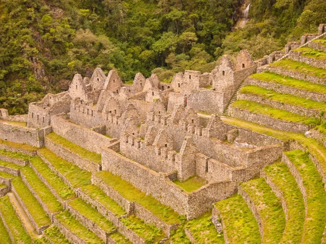
The terraces are the site’s most recognizable feature. Stone retaining walls support successive platforms that follow the hillside, creating a striking pattern across the slope.
Their agricultural role helps explain why the complex extends beyond its buildings. The terraces transformed steep ground into more usable surfaces, showing how cultivation was incorporated into the design of a mountain settlement.
For a better understanding, look at the relationship between the platforms and the nearby access routes. A wide photograph captures their overall shape, while a closer view reveals the height of the walls and the changes between levels.
Upper and Lower Buildings
Groups of stone structures occupy upper and lower sections of the site. Their arrangement reflects the challenges of building on uneven ground rather than around a single level square.
Look for doorways, niches, and surviving wall surfaces. Trapezoidal openings are among the architectural details associated with Inca construction.
The quality and appearance of the stonework vary across the complex. These differences reward careful observation, but they do not justify assigning a precise function to every room. A guide can help distinguish visible architectural evidence from interpretations about how particular spaces were used.
Connecting Stairways
The stairways make the site’s vertical organization easier to understand. They link different sections and reveal distances that can seem compressed in panoramic photographs.
As you move through permitted areas, notice how steps relate to terraces, buildings, and water features. Circulation was part of the overall design, allowing people to navigate an environment where changes in elevation shaped everyday movement.
Fountains and Water Channels
Water features are another important part of the visit. Structures beside the stairways show how water was directed through different levels of the complex.
These installations are often described as fountains or baths. Some interpretations emphasize ceremonial use, but the structures alone cannot establish the exact rituals that may have taken place.
What visitors can observe is the deliberate relationship between water and architecture. Following the channels visually provides a different perspective from simply looking at the terraces.
The Cloud Forest Around the Ruins
The setting of Wiñay Wayna adds another dimension to its archaeological importance. This section of the trail passes through humid mountain environments where ferns, mosses, orchids, and other plants contribute to the dense greenery.
Compared with the more open landscapes encountered at higher elevations, the forest can feel enclosed and lush. Clouds sometimes conceal the surrounding slopes before clearing to reveal the valley again.
Birds, butterflies, and flowering plants may become part of the experience, although wildlife sightings are never guaranteed. Slowing down and listening can be as rewarding as searching for a panoramic viewpoint.
For photography, combine broader landscape images with details of vegetation and stone. This approach captures how the ruins sit within their environment rather than presenting them as isolated buildings.
The Connection with Intipunku and Machu Picchu
Wiñay Wayna helps visitors see Machu Picchu as part of a wider cultural landscape. The surrounding paths, agricultural areas, and settlements show that the famous destination did not exist in isolation.
From this section, the trail continues toward Intipunku. The Sun Gate marks an important stage in the approach, with views of Machu Picchu depending on visibility and weather conditions.
The three places should be understood separately: the terraced complex, the gateway, and the larger archaeological destination each contribute something different to the journey.
Instead of treating the final stretch as a countdown to arrival, use it to notice connections between landscape and construction. This makes the experience richer and gives the smaller sites their own place in the story.
How Can You Visit the Site?
Reaching Wiñay Wayna involves walking along authorized routes within the regulated Inca Trail network. The complex features in classic itineraries and in the shorter approach associated with kilometer 104.
MINCETUR’s description of the shorter route specifies an official permit and an authorized guide. Visitors should not assume that a standard Machu Picchu admission ticket grants access to this section of the trail.
Before planning your journey, confirm the permitted route, current access conditions, and any conservation notices. Maintenance or ground conditions can affect which sections are available.
You can explore the Inca Trail understand the available approaches and ask which itinerary includes the archaeological site. This is also an opportunity to confirm how much walking the route involves.
Tips for a More Meaningful Visit
Start by looking at the whole hillside, then focus on three elements: the terraces, the connections between buildings, and the water system. Together, they make the layout easier to understand.
One useful exercise is to notice how your perspective changes after climbing or descending a few steps. From one position, the terraces dominate; from another, a doorway or channel becomes the main feature.
Allow yourself a moment to compare the view with the details immediately beside the path. A distant terrace may look simple until you notice the stonework supporting it. Looking at both scales helps turn an attractive scene into a clearer understanding of the practical decisions involved in building across such a physically demanding mountain landscape.
Stay within the designated visitor areas. A terrace that appears accessible in a photograph is not necessarily open for walking, and temporary restrictions help protect fragile structures.
Avoid climbing walls, leaning on ancient masonry, or placing belongings on archaeological features. When taking photographs, leave room for other visitors to pass safely along narrow stairs.
Keep your rubbish with you and leave plants undisturbed. Questions also improve the experience: ask your guide which details are documented and which explanations remain interpretations.
Approaching Wiñay Wayna with curiosity turns a scenic stop into an opportunity to understand Inca design. Its terraces, stairways, and fountains preserve an important relationship between people and mountains, adding historical depth to the route toward Machu Picchu.


